
This part covers the section of Route 66 from it’s entry point into Oklahoma to Tulsa. The old Route 66 in this part is usually far away from Highway 44. It only intercepts Highway 44 close to Afton and then Vinita.
You leave Kansas driving south on Highway 69 Alt. As soon as you cross the state line you will come across the Indian Territorial Memorial on the side of the road.
Indian Territory was established in 1834 as a designated area for the relocation of Native American tribes, primarily in what is now Oklahoma. This territory was created following the Indian Removal Act, which aimed to move Native Americans from their ancestral lands in the eastern United States to lands west of the Mississippi River.
The Quapaw or Arkansas, is a U.S. federally recognized tribe comprising about 6,000 citizens nowadays. Their ancestral homelands were around from the Ohio River to the Mississippi River, south across present-day Arkansas and eastern and southern Oklahoma. The government forcibly removed them from Arkansas Territory in 1834. The tribal capital is Quapaw where the sign is located. Continuing south on the road you will arrive at Quapaw.

After a few turns on Highway 60 Alt. you will reach the town of Commerce.
This is part of the Tri-State Mining District. In the early 1900’s miners arrived attracted by the deposits of lead and zinc. The company that operated some of the mines in the area was “Commerce Mining and Royalty Company”. Very soon the local post office located on the mining campground and north of the nearby town of Miami started to re referred to as Commerce Post Office.
Most mines closed by 1960, due to a declining market and the realization of extensive environmental damage to ground, water and air.
The activity left giant piles of toxic metal-contaminated mine tailings, known as chat, scattered throughout the area. The site being included in 1983 in the Tar Creek Superfund site by the US Environmental Protection Agency.
You can still witness the environmental damage driving around the abandoned town of Picher. Nearby there are other ghost towns abandoned by the same reason: Cardin, Treece and Douthat.
Picher is among a small number of locations in the world (such as Gilman, Colorado; Centralia, Pennsylvania; and Wittenoom, Western Australia) to be evacuated and declared uninhabitable due to environmental and health damage caused by mining.
Most of the buildings with exception of the ones with historical value have been demolished. It is an eerie atmosphere with large dunes of toxic material laying just next to the highway. The mascot Picher Highschool Gorilla Mascot statue is still standing.


A little later down the road you arrive at Commerce.
There are two interesting facts about Commerce. The first is that on April 6, 1934, Bonnie and Clyde and their associate Henry Methvin killed Commerce Constable William C. Campbell and kidnapped police chief Percy Boyd. By Forty seven days later on May 23, Bonnie and Clyde would both be dead.
In 1935, Elvin Charles “Mutt” Mantle moved to commerce to work as a miner. He was the father of Mickey Mantle.
Mick Mantle played his entire Major League Baseball career (1951–1968) with the New York Yankees and is regarded by many as one of the best players and sluggers of all time. He was nicknamed “The Commerce Comet”. Mantle was born on October 20, 1931 in Spavinaw in Oklahoma.
His boyhood home is a well preserved historic building and there is an statue of Mickey Mantle next to the baseball field.


Commerce is very close to the next town of Miami. The city was founded in an unusual way. It was settled in a business-like way. Wayland C. Lykins met with met with Thomas F. Richardville, chief of the Miami tribe in Oklahoma and Manford Pooler, chief of the Ottawa Indian tribe of Oklahoma. In the meeting. After the meeting Lykins petitioned the U.S. Congress to pass legislation on March 3, 1891, to establish a town on land purchased from the Ottawa. Lynkis invited Richardville to name the town and he chose the name of his tribe, Mi-am-UH.
Lykins donated $30,000 in property so that the Kansas City, Ft. Scott, and Memphis Railway would run tracks into town. In 1905, lead and zinc were discovered while drilling north of town on Indian-owned land. That led to the founding of the Emma Gordon Mine, and riches for four investors: James F. Robinson, Charles M. Harvey, George L. Coleman, and his borther Alfred Coleman. Lots more mines would be drilled in that area, and mining would be Miami’s main source of income until the middle of the 20th century.
Miami was on the route of two important highways. One, the international Jefferson Highway established in 1915, running more than 2,300 miles from Winnipeg in Canada, across the border and to New Orleans. The other was Route 66.
George L. Coleman became a magnate. His mansion, located in Miami, is listed on the National Register of Historic Places. He also constructed his legacy, the Coleman Theatre in Miami. The theater is still in operation and offer tours on some days. A must stop when going through town.
Other photo opportunity is the Waylans Ku Ku Burger fast food, the last still in operation restaurant from the 60’s store. It is shaped in the form of a cuckoo clock. There are plenty of very dilapidated remains of old gas stations and motels along the road. The gateway sign at the south end of main street is also interesting.


The original Route 66 was pieced together linking different State highways, and these roads had different surfaces, paving and even widths. The famous “Sidewalk road” or “Ribbon Road” is a very narrow section of the Mother Road.
A short distance south between Miami and Afton you will come to this very old segment of Route 66 that predates the creation of the highway as was completed between 1921 and 1922.
This section has a paved surface that is only 9 feet wide, flanked by two five-foot gravel shoulders separated from the road by white cement spacers. This is the only place along all the 2,448 miles of Route 66 where you can still drive over the most original section of the road. It is so narrow that Carioca tires were at the edge of the road.


The road then continues towards Afton after crossing I-44. From there the road continues towards Vinita just after crossing again I-44. Route 66 is known for the many ruins of left behind gas stations, restaurants and other businesses. This stretch of the road has several. In Vinita you can stretch your legs, get something to eat and visit the Eastern Trail Museum.


You now continue towards the town of Chelsea. On the way you will have some interesting places for some photo opportunities such as the Hi-Way Cafe and the Pryor Creek Bridge.
Oklahoma was the largest producer of oil in the world in 1907. It maintained this status until around 1930, when it traded the title with California.
The discovery of the Glenn Pool Oil Reserve in 1905 brought the first major oil pipelines into Oklahoma, and instigated the first large scale oil boom in the state. Located near what the town of Tulsa. The resultant establishment of the oil fields in the area contributed greatly to the early growth and success of the city, as Tulsa became the petroleum and transportation center of the state, and the world.
During the boom, several Creek Indian land allotment owners became millionaires; Oklahoma became the world’s largest oil producer for years; and the area benefited from the generation of more wealth than the California Gold Rush and Nevada Silver Rush combined, as well as the increased investment capital and industrial infrastructure the boom brought with it.
Several other major oil discoveries were made. Discovery of oil in the lands of the First America Reservations blessed Native Americans with enormous wealth. The dark side of this is well portrayed in the movie Killers of the Flower Moon by Martin Scorcese.
It all had a very humble beginning with the discovery of the first oil well in Oklahoma. There are many claims to the first oil well in Oklahoma
Just little after Chelsea, on the south side of E 350 Rd between S4100 and S4200 Roads you will find an old oil well from 1889. Unfortunately it was not the first as the sign says. The First Oil Well in Oklahoma was drilled in 1885 in Atoka County, Choctaw Nation, Indian Territory, although it was not completed until 1888 and died shortly after. This may have been the second to be able to hold production for a while. However, many claim that was the Nellie Johnstone No. 1 well near Bartlesville drilled in 1897 was the first commercial oil well in the state.
Still an interesting historic place for a quick detour and stop.


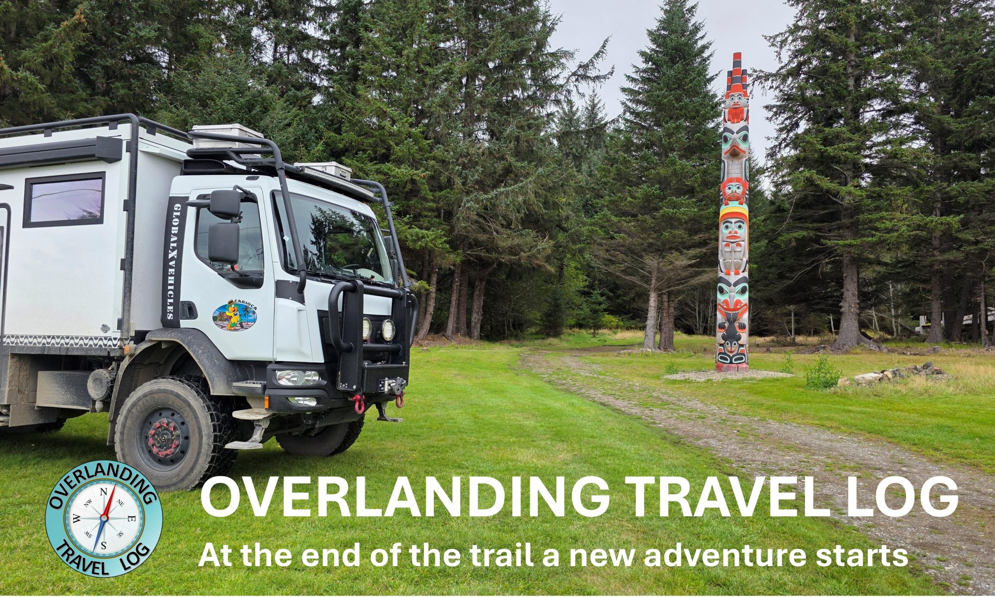
Ed Galloway’s Totem Pole Park is a park created by American sculptor, woodcarver, and folk artist Ed Galloway starting in 1937. It is located a couple of miles east of Route 66 just before Claremore.


Claremore is home to the Will Rogers Memorial Museum.
William Penn Adair Rogers was born on November 4, 1879 and died on August 15, 1935. He was an American performer, actor, and humorous social commentator. He was born as a citizen of the Cherokee Nation, in the Indian Territory (now part of Oklahoma), and is known as “Oklahoma’s Favorite Son”.
The museum houses artifacts, memorabilia, photographs, and manuscripts pertaining to Rogers’ life, and documentaries, speeches, and movies starring Rogers are shown in a theater. His tomb is located on its 20-acre grounds overlooking Claremore.


A little north of Claremore is the site where Will Rogers was born. It certainly worth a visit too. It is called Will Rogers Birthplace Ranch.


You return to Claremore and continue on historical Route 66 towards Claremore.
There are some points of interest along Route 66 that stands out by their visual appearance. Several are located in Oklahoma and the Blue Whale of Catoosa is certainly the most recognizable one. It is not from the time of the original Route 66.
Local zoologist and artist Hugh Davis and his friend, Harold Thomas, built the Blue Whale in the early 1970s out of iron and concrete. It was a surprise gift to Davis’ wife Zelta, who collected whale figurines. It was revealed to her on September 7, 1972 for their 34th wedding anniversary. The Blue Whale and its pond became a favored swimming hole for both locals and travelers along Route 66.


The last attraction on this historic section of Route 66 before it merges with I-44 is the D.W. Correll Museum. This is one of the many museums along the road where collectors displays their historic artifacts.


From here Route 66 disappears as it merges with I-44 and other Tulsa roads and streets.
Discover more from Overlanding travel log
Subscribe to get the latest posts sent to your email.
Olá Maurício e Lídia ,
Muito obrigado por compartilhar essa experiência! Ficou ótima a parte histórica deste percurso. Não que os outros não tenham ficado legais, mas me identifiquei mais com esse, e também de Yellowstone.
Bons passeios.
Júlio Noronha.
Obrigado. Este post é uma montagem com pedaços de outras viagens. Nunca viajamos pela Rota 66 por si só. Mas passamos muitas vezes por vários segmentos quando a caminho de outros destinos. Resolvi colocar tudo junto numa série de posts resumindo o que é a Route 66. A parte histórica deste tipo de vídeo dá para inserir no post sem ele ficar muito longo. Que bom que você gostou.